Tag Archives: featured

Persuasive Cartography

Persuasive Cartography | The PJ Mode Collection at Cornell University.

Credit: Cornell University – PJ Mode Collection of Persuasive Cartography

World in a Cloverleaf (1581) Bünting, Heinrich, 1545-1606

Credit: Cornell University – PJ Mode Collection of Persuasive Cartography

The Attack of Love (1730) Seutter, Matthaeus, 1678-1756

Credit: Cornell University – PJ Mode Collection of Persuasive Cartography

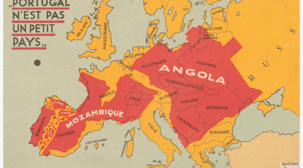
Portugal is Not A Small Country (1934) Galvão, Henrique, 1895-1970

Credit: Cornell University – PJ Mode Collection of Persuasive Cartography

B.C. 2348. The Deluge (1836) Hall, Sidney

Credit: PJ Mode Collection of Persuasive Cartography

Cross Section of Hell (1855) Caetani, Michelangelo

Credit: PJ Mode Collection of Persuasive Cartography

Overview of the Divine Comedy (1855) Caetani, Michelangelo

Credit: PJ Mode Collection of Persuasive Cartography

Genealogical Chronological & Geographical Chart [left] (1887) Skeen, Jacob

Credit: PJ Mode Collection of Persuasive Cartography

Map of the China Seas (1898) Duncan, W. B.

Credit: PJ Mode Collection of Persuasive Cartography

Chicago’s Gangland (1927) Thrasher, Frederic M.

Credit: PJ Mode Collection of Persuasive Cartography

What Germany Wants (1917) Edward Stanford Ltd.

Fukuoka New Year’s Day

students-DSC_1881New Year’s day. Students near Hakata station.croissant-DSC_1885Had delicious croissants from Il Forno Mignon at Hakata station.Komainu-DSC_1896Komainu 狛犬 at Sumiyoshi shrine 住吉神社. Komainu-DSC_1908sumo-DSC_1925 sumo-DSC_1931Statue of an ancient sumo wrestler revisited.Komainu-DSC_1936Komainu.dog-DSC_1940A dog and his master waiting in line at the shrine.dog-DSC_1942An older couple arrived at the shrine with their respective matching pups. dog-DSC_1945demon-DSC_1951canal-city-DSC_1953Canal City.

kenzo-tonkotsu-DSC_1960 kenzo-tonkotsu-DSC_1962Kawabata shopping arcade.  wrestlers-DSC_1964We were all wrestlers in Japan once.

cat-DSC_1980ネコ. Ca ca catters mccatters ©.   ACROS-DSC_1982ACROS.dog-DSC_1994A little papillon near Watanabe dori.

robot-DSC_2005Had the creeping sensation of being followed.

yatai-DSC_2009Found some yatai 屋台 at the edge of the city. I got excited about a yakuza-looking guy hanging out near the joint that had part of his little finger missing.  She was more excited about the food.

yatai-DSC_2012  Some of the best ramen noddles I’ve had under a plastic tarp.

yatai-DSC_2017fukuoka-castle-DSC_2030Walked the ruins of Fukuoka castle in the dark.

subway-DSC_2036Headed back to our Hakata base. ohori-DSC_2038

Save

Navajo Peak and Airplane Gully

navajo-peak_DSC5236

Navajo Peak and Airplane Gully. Part of the wreckage of the DC-3 can be seen below the center of the picture.

Excepts from the 1948 Accident Investigation Report:

[Aircraft] NC-206 [DC-3] departed from Denver, Colorado, at 1602 [January 21, 1948] for Grand Junction, Colorado.

navajo-peak_DSC5348

Twenty-two minutes later, at 1624, the CAA communication station at Denver received a position report from the flight that it was at an altitude of 14,500 feet, 500 feet over the top of clouds, and 20 miles west of Denver. The flight also reported that they were experiencing severe turbulence.

navajo-peak_DSC5350

At approximately 1630, aircraft NC-206[…] crashed 7 miles west southwest of Ward, Colorado, on Navajo Peak. The 3 occupants aboard were killed, and the aircraft was completely destroyed.

navajo-peak_DSC5359

Impact and fire which followed completely destroyed the airplane.

navajo-peak_DSC5386
A search was organized, and in spite of snowstorms and unfavorable weather on the night of January 21, 1948, search parties moved into the mountainous area from which the aircraft had last been heard. Snow continued for 7 days, covering the wreckage, and making it practically impossible to locate from either the air or the ground. As a result, the search parties were recalled January 28, but the aerial search continued. On May 23, 1948, the wreckage was located by an Air National Guard. It was found slightly below the summit and on the north side of Navajo Peak, which is approximately 7 miles west southwest of Ward, Colorado, or about 45 miles west northwest of Denver. Immediately after the wreckage was located from the air, a ground search party was dispatched to the scene […]

navajo-peak_DSC5333

The search party found that the aircraft had struck the north northeast side of Navajo Peak approximately 500 feet below the summit, and at an elevation of 12,900 feet above sea level. […] First point of impact was on an almost vertical wall of rock, and the places where the engines had struck were clearly defined by oil spots and scars in the rock.

navajo-peak_DSC5311navajo-peak_DSC5267navajo-peak_DSC5288navajo-peak_DSC5372

Probable Cause
The Board determines that the probable cause of this accident was an excessive loss of altitude resulting from a downdraft in an area of severe turbulence.

One of the men that died in the accident was survived by a four-month-old son.

Navajo Peak, Indian Peaks Wilderness.

Save